
The JSNA Profile Reports provide a set of topic-based “Profiles” for the JSNA areas in Warwickshire. They include a range of statistics from official sources such as the Office for National Statistics and where possible, data collected by Warwickshire County Council. These figures will be regularly updated, in line with published sources.
From the JSNA tab, the drop-down menu includes “JSNA Profiles” – select the topic of interest to open a Profile Report.
The “Select a Geography” option has been pre-set to “JSNA” and by default, the first report to open is for Atherstone and Hartshill. To switch to another JSNA, click in the “Select an area” box and pick an area from the drop-down list.
The JSNA Geographies were approved by the JSNA Strategic Group in June 2017. A reference map showing the 22 geographic areas can be found here:
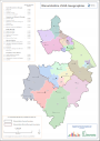
JSNA Geographies (July 2017, PDF, 608 KB)